Monday 31 March 2014

Walk 19 Aberystwyth to Tre'r Ddol 30th March, 2014

Mother’s Day! Also the clocks sprang forward overnight so to bed early last night – then up at 6.45 and off by 7.30. The tops today were just normal – lovely views and bright with promise of a sunny, warm day ahead. We had arranged to meet the taxi at the community shop/café at Tre’r Ddol at 9. The café people had agreed it was ok to leave the car there so we bought our sandwiches there.....and very nice they were too! The taxi took us back to the castle where we had a quick look around before setting off at 9.15.
The seafront is recovered now from the storms – it did suffer on the seafront, losing its old bandstand. But the defences had held up, the pier is still there and the town had no serious flooding…
I had hoped we would get up Constitution Hill using the funicular railway….

but it is closed til the middle of April! So up the hill we went – is that where the term taking a “constitutional” comes from I wondered? The only view of the railway was from the bridge crossing it ...uphill!..
On top of the hill is the world’s largest Camera Obscura….and views of the walk ahead..
Up on top we soon saw the caravan village ahead of Clarach – that was the settlement we had been viewing yesterday wondering if it was Aber. It was near Clarach where we realised I had left the map in the car….good job we had a good idea of the route today…hopefully! 
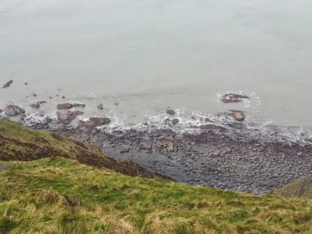
We had good views back too looking over Aber and to New Quay and just about to Mwnt and maybe a bit further although it was still too hazy for it to be really clearly seen. It was really bright all day but still too hazy to see the Lleyn ( it was Barmouth, not the Lleyn, Pam!) Up again onto the clifftops once we passed Clarach – and it was a real cliff walk today with many ups and downs all the way to Borth. We soon saw the highlight of our day – Sarn Gynfelyn. 

There are at least 3 Sarns in Cardigan Bay, the other 2 further north which we hope we’ll see too – causeways caused by glacial moraine which go out into the sea for 7 miles or so. It’s said that these Sarns are really the edges of a sunken settlement, Cantre’f Gwaelod which was inundated when the keeper looking after the locks to keep the sea out went to sleep and the whole place was flooded. It was an amazing sight with waves 
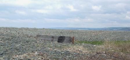
breaking all along it and on its beach was a lime kiln. 

Lots of debris from the storms was washed up here and there were 2 houses at the settlement, Wallog – what an idyllic place! 

There were guinea fowl pecking away in the nearby field – quite a strange sight! As we climbed away we kept looking back and out to sea – could we really see the edges of Cantr’f gwaelod, Ceredigion’s Atlantis?

 We had a nice chat with a couple form Bristol who are walking the coast path in stretches. They completed the South West path some time ago. Lots of big cliffs were to follow, sometimes the only useable gear was crawler! – and it was quite hot and sunny! 
Soon we could see Borth and make out Aberdovey across the estuary 
before we dropped down to the caravan park at Pen-y-Graig beside a lovely beach and the outcrop of Carreg Mulfran 
and so up the last hill before Borth with its war memorial on top. 
Walked down this last descent and had lunch overlooking the sea gently washing into Borth, the tide was on its way out. A chap told us the seas had been really wild and high here in the storms. We headed down Borth High Street, The end of the Ceredigion coast path is actually at Ynyslas which is about 3 more miles beyond Borth with its lovely high sand dunes, which our grandsons love, and which looks across the river Dovey to Aberdovey. The coastal path though crosses the railway near Borth station – the driver gave us a wave! 
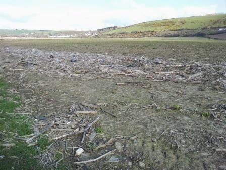
And so began the second half of the walk. It was a walk of 2 halves today – cliff top coastal – and now along a flat bog and estuarial. We have now to head around the River Dovey. Borth Bog – or Cors Fochno – nature resrve. The whole of the Dyfi estusry area is the only UNESCO biosphere in Wales and indeed it did make a lovely walk across the bog, through reeds, crossing the river Leri which was canalised in the late 19th century, 
passing ditches where man has drained the land and from which ducks flew as we passed, and where alders were just bursting into bud.... 
The hedges have become more and more green over the past few days of our travels. Towards the end of the bog, it was a long 2 mile stretch as straight as an arrow....
.....and which we were now looking forward to reaching the end of as it was really hot in the sun, over 20 degrees it turned out. Luckily the bog wasn’t too boggy today – it has had a few dry days so we didn’t get too wet. Soon we could see the village of Tre Taliesin appearing across the fields and shortly we reached the A487 to walk into Tre’r Ddol ..
....where we enjoyed much liquid refreshment at the café and where lovely people from Machynlleth gave us very kind donations – and also good advice about path on the way to Aberdovey – thank you! So almost goodbye Ceredigion now, a brief pass through Powys at Machynlleth and then comes Gwynedd! Another 11 miles off the total.....


Walk 18 Llanon to Aberystwyth 29th March, 2014

Can't believe we're almost at Aberystwyth.....more than halfway now and hoping for some more sponsorship from recent letters....keep a lookout at www.justgiving.com/pamela-mallpress We left home at 7.30 headed to Aber for taxi pick up at 9.30. Today it was misty over the tops so promising to be warmer after the snow we saw Thursday! Back in Llanon and began walking by 9.45. Down Church Street and passing the pretty church at Llansantfraed which is really a hamlet joined on to Llanon. 

Continuing along the flat levels beside the sea with the tide well out so we had lovely pavements to see all day at the foot of the cliffs. We passed through a field of heifers or bullocks, young cattle anyway who wanted to follow us – but I was brave! We shouted at them in a Yorkshire accent as it sounded fiercer! 

We soon came to the 4 lime kilns we had read about at Craig-las with remains of jetties on the shore in front of them. 

Another strange sight of previous industrial scenes – we thought it must have been a businessman who wanted to take the whole lime market hereabouts! Once again we passed the scene of much rock throwing into the fields by the sea in the storms. 

Arriving at the shingle bank going into Llanrhystud, we were met by a Land Rover coming towards us across the bank – quite precarious we thought! 

There was an iron age hill fort in Llanrhystud, Gaer Penrhos, which had subsequently had a Norman castle built within its earthworks but it is on private land about 1 mile east of the village so we couldn’t see it today…we had to press on. In Llanrhystud we had to go inland to avoid a caravan park and then go around the edge of another one before going up onto the cliffs once more.  

It was a lovely walk up on the cliffs with not too many ups and downs yet but with much erosion and lots of contorted trees! It was a bit hazy but bright so the views were not clear but we could look ahead at the ridge we had to follow today. 

We could dimly make out a settlement in front – was it Aber? And we thought we could make out Ynyslas ahead too..... maybe. I kept looking down at the pavements..

And glancing back at the route we had completed...

We lunched at Penberi cliffs – quite magnificent cliffs and a nature reserve where fulmars and cormorants like to nest. We had seen cormorants skimming low over the sea.
And the trees here are some kind of oak which grow only stunted because of the weather conditions.
And as I said there were many contorted trees along the way...
We passed a farmhouse being renovated in a lovely setting
and walked though fields full of proud ewes with their new lambs
and then reached another farmstead at Ffon-las, but this one is a complete ruin..and we had to walk up a high hill to go around it too!
We were high above the sea again with lots of erosion and landslip of the soft rock here and there..
Passing another farmstead and then arriving at Morfa Bychan and its caravans meant we dropped down steeply only to go up steeply again back to the cliff tops. Really lovely views and then it was quite surprising how remote and wild it felt here although we were now so close to Aber! It’s said that the finest views in Ceredigion are to be had up here – both inland and coastal – which we could believe, but not so today with the haziness. Perhaps as well thought Chris ....so we couldn’t see how far we still have to go to the Lleyn! The cliffs here had strange formations along them – sometimes looking like they had been mined,
sometimes with deeply striated stripes,
sometimes a landslip
– and all with amazing pavements at their feet with a gentle sea today. We had had some breeze on the tops now and again but not a lot and it was much warmer today. Great views as Aber came into sight over the final cliff top of this escarpment
– its harbour, castle and Pendinas hill (a hill fort – now with a monument on top, in celebration of Wellington’s Waterloo victory). We dropped really steeply down to Tanybwlch beach with its huge shingle bank – again signs of the strength of the storms although the bank had been mostly put back to where it should be now! A nice walk into the harbour....
having crossed the river Ystwyth and then crossing the bridge over the Rheidiol, back to the car park. A lovely day – one of the best so far. 12 more miles along the way!

We saw lots of kites again, the ubiquitous skylarks and some gulls and cormorants. Celandines and violets – dandelions and primroses....Fishermen at Aberystwyth...

More to do tomorrow along this lovely Cardigan Bay......

Friday 28 March 2014

Walk 17 New Quay to Llanon 27th March, 2014

Hello again! Have to get up Cardigan Bay now before 3rd May when we have the next house booked so as the forecast looked good for yesterday, 26th and today I was hoping that my met skills were not going to let me down….we left home 7.30am and over the Cambrians it was only 2 degrees with frost on the trees
and snow on the tops!
We arrived Llanon early and waited for the taxi at 9.30 to take us back to New Quay – it seemed far! The Polish driver told us the council may close the Llanarth road into New Quay where a landslip has been waiting for fixing for 2 years – crazy councils! It was a lovely morning if a bit chilly as we set off down to the beach, as our walk began about 10, the tide was well out and we knew it was low tide until midday so we had a lovely walk right along the beach.

It was amazing how folded the cliffs were along here...

a waterfall was tumbling down and here and there the rock changed to a soft one which showed erosion signs. The sea was gently rolling in as we headed across the beach,
with views back to New Quay...
We walked across to Llanina point and although we could have continued along the smaller Cei Bach – small quay, we didn’t know how far we would have been able to walk and how we would have got back to the path so we followed the waymarkers which took us inland. Here we saw a very pretty little hamlet – its church now a home but ruins were here and there in the woods. We got slightly lost around a farm where the waymarkers weren’t visible but a man kindly directed us through the farmyard and back out on to the clifftops. It was a lovely walk above Cei Bach listening to waves below us, looking back to New Quay and Llanina Point.
Soon we came upon a lovely little cove where the river Drywi formed amazing terraces of rock falling down its valley

and it fell in a waterfall to the beach below – it was really very high…and very pretty.

Fairly shortly we had to turn inland to avoid the private holiday village of Gilfach– the view towards Llanon and beyond was tantalising – we couldn’t quite decide which settlements beyond we could see through the haze but decided it couldn’t be Aberystwyth.

It was really only possible to see as far as the end of the land around Harlech today – the Lleyn and the mountains were not really possible to pick out. The view back was good too - I loved the windblown trees!
We soon came across another lovely little cove at Cwm Clifforch – a bit like a more gentle Pwll y Wrach or Aber Castell. Strange land formation formed from erosion but a lovely setting nonetheless..
We had a lovely walk then as we approached Aberaeron, passing a group of people going towards New Quay who live in Aberdovey who kindly gave us donations – we’ll be there before long!

And so down to Aberaeron – the huge council building being about the first building we passed ..
and then lovely colourful housing around the harbour.
Aberaeron was very busy with boatbuilding in its past – and lime weighing. It has its own Lime Weigh house! Onwards then after a lunch stop...
across a shingly path which then turned to a grass one – all along here it was clear to see that the sea had wrought a lot of damage in the storms...here a breakwater no longer breaks the waves but instead is covered in the shingle - some boulders as big as your head! - dumped by those powersul, storm driven waves, incredible!
And the soft cliffs along this stretch were badly, and recently, eroded...
...as we approached Aberarth, very pretty with its river Arth - and the only dolphin we saw of the day – was here on a gate!
Out once more along the cliffs – further examples of the erosion of the cliffs - here the undercut was stunning to see, with its inherent danger...
And here and there the fence posts had been gradually - or in some cases, urgently, been moved back landwards...
Looking back, New Quay now seemed quite far away - and those wind blown hedges made great shapes!
As we were approaching Llanon, there was one amazingly high cliff, seemed out of place amongst so much soft rock.
Soon we were headed on lower ground into Llanon and now we could make out the nearer hills more clearly. It was an easy final walk into Llanon alongside the sea and sometimes on the shingle bank which again had encroached such a long way into the fields.
And why so many plastic bottles washed out of the sea?
The sea also showed us its gentle side, here with patterns almost like lace as it rolled in to the shore....
.....and then again its stormy side, here taking over a field – of turnip here – ready salted now!
What storms we had! What strength! The coast route sort of ran out here – think it goes onto the beach but the tide was coming in now so we headed up to the road into the village back to the car. A lovely walk on what did turn out to be a lovely bright day.
It snowed on us going home over the Cambrians so hope the weather reporting goes well for the next few walks…..Saw the first fisherman on Cei Bach since we saw some at Amroth – whose road was pretty much destroyed after the storms by the way.
Another 12 miles further!