What a finish....can it be true! Still reeling really with the fact that we did it!! And still quite tired.....just as well we're at the end maybe.
First of all a big thank you for all the support from my wonderful family and especially to Paul and Jane in New Radnor who came to join us too. Paul promised on new Year's Eve last year he would walk the last 5 miles with me - and he did!! (Don't think he'll be speaking to me this New Year - just in case I have another plan......).
Lots of other big thank you's for so many kind donations - really so much appreciated as that was what the whole idea was about. Arthur's godfather's family even held a coffee morning raising so much - thank you, Kim.
I have produced a calendar with pictures of our walk which I am selling at £6 - the whole profit going to the appeal - I really hope to reach that £4,000 target and it's getting nearer after so much kindness. If you would like a calendar, you can email me at pamelamallpress@btinternet.com with your address and put the £6 on www.justgiving.com/Pamela-Mallpress and I will post one to you. This is the front.....
It's A4 size - it was hard choosing just 12 pictures!
When we got back from the walk, we received in the post our Anglesey certificates - and they are lovely! The wording is really meaningful - and enticing you to go and do it again. Well - it was one of my favourite parts....
Have written to the WCP to ask if there is a certificate for the whole thing but I did make myself one anyway! So - on with the story's conclusion....
Thursday 25th
September
Prestatyn to Holywell (Greenfield)
Off we go
again….didn’t seem much of a break but here we are….final lap!
Left home
by 7 and it was a pretty sunrise with mist hanging in the valleys.
This time we
went via Welshpool….seemed different leaving the old route behind but it's still a pretty route...
. Not too bad a journey….3 hours back to
Prestatyn, it didn’t seem long since we finished here. A bit cloudier and
breezier today and quieter too ..and we could see the wind farm, with some
turbines going round too.
So off we set down the prom.
The beaches here are
lovely, sandy and big. Looking back there was the Great Orme reaching out into Liverpool Bay.....
The last
beach
of Prestatyn is Barkby
and we walked along the beach just past there up to the Gronant dunes, now
getting closer and closer to the Point of Ayr and its lighthouse…..we would be
leaving the sea behind for the last time. The sky over the Wirral was looming black but the rain held off all day....the mist rising from the waves contrasted with the black clouds...
We left the beach for a while where
it grew stoney. Chris has quite an injured foot now so the stony ground wasn’t
what we needed so we took to the path through the huge dunes for a while.
Some
sea holly was still trying to flower but most had gone to seed now. Restharrow
was still showing a pretty mauve face here and there.
We couldn’t resist a
boardwalk out to a viewing point at the beach –
looking ahead to the Wirral
over the
Dee
and back to the Great Orme!
Always with the wind farm on the horizon here.
Back through the dunes we
approached Presthaven sands via a caravan park although we didn’t go through,
or even see, the park. Then along the sands again where so many gulls and waders were gathered...
Here the coastal path signs have the path symbol in a big wooden sign.
And we came across quite a few signs with high tide alternative paths on these couple of days - only caught us once later in the day when we had to retrace steps!!
I loved this beach walk maybe more than others because I knew it was the last one. I enjoyed listening to the waves and watching them burst onto the sand even though they are quite muddy looking waves here being near the estuary and today the wind was driving them in a bit fast...
The
little tern is a special visitor along this coast, the only part of North Wales
where it travels the 3,000 miles from
West Africa
to nest. Apparently they love the sand eels here! There were lots of gulls and
oyster catchers! My favourite!
And the natter jack toads are protected all
around the coast here, right across to the
Hilbre Islands
off the Wirral. We didn’t see the toads today. We walked right at tide’s edge,
lovely! Views here across to the West Hoyle wind turbines and lots of razor
shells dumped by the waves crackling underfoot.
Then we passed the old Point of
Ayr lighthouse on Talacre beach. A bit of a sad sight as it has been out of use
since the late 1800’s.
I think a lightship took its place – today only the
waves were keeping it company. Just here a whole school – it seemed a lot – of
children passed going beachcombing. And so we got to Point of Ayr – we couldn’t
actually walk to the very ends as the RSPB had a STOP sign out though we didn’t
think birds would still be nesting now. There were a lot of birds here though.
We even saw some sanderlings and ringed plover flying off over the waves….
We
stopped for lunch overlooking the spit at the Point
and behind us the gas
refinery which refines gas brought in from
Liverpool Bay.
Down river we could look ahead to the gas fired power station at Connah’s Quay
and the big chimney of the paper mill nearby. We continued passing the refinery
and around a huge old industrial site that was the last deep coal mine in north
Wales which closed only in the late 1990’s. Now it is just a huge old reminder of times gone by, all gone to seed, with its own railway sidings. It’s now taken over by elderberries,
blackberries – and lots of trees, all now showing more and more of their autumn
colours.
We headed a little inland then where more of the path is being
landscaped and then crossing fields and roads, we headed into the
village of Ffynnongroyw (must have been another
old spring or well here, Ffynnon-well in Welsh). We walked along its High Street and
approached the main road again where we noticed the first coastal path
signs/buttons, in the footpath itself!
Another new sign today. We had the
choice here to take a high road over the hills or keep to the low road – which
we preferred today. We couldn’t beachwalk the estuary here as it was coming
into Mostyn Docks and, tightly alongside estuary, is the railway.
So we road walked
here into Mostyn. Mostyn docks is still a busy place. It supplies lots of
material for the wind farms and an important part of its activity is sending
Airbus wings from here to
Toulouse!
The wings are made just upriver at Broughton and sent to Mostyn on special
rafts before being sent on their way. There have been docks here since Norman
times – at least I should think, probably longer.
It was from here that Henry Tudor escaped from
Richard III and went into exile, before returning to beat Richard when he
sailed back to
Mill
Bay in Milford Haven,
remember? It was Henry Tudor as King Henry who made the first Lord of Mostyn,
giving this land up as far as Llandudno to him. We were able to turn away from
the road again here and headed along the estuary. We saw another curlew and
lots of oystercatchers and other wading birds too far away to see.
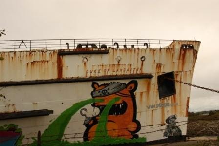
Soon we came
to the old ship the Duke of Lancaster which has been left here since the 1970’s.
It was intended to be made into a hotel, then an adventure park but nothing
happened, though it was once a market apparently.
Don’t know if it was because
of no planning or lack of money that it has just been left – quite a sad sight.
So we headed down the side of the
Dee. Huge
rocks along the water blocked our view – more signs of anti flood defences. At the tip of the Wirral we could see the Hilbre Islands which are easily accessible at low tide over the sand flats there. (Wirral apparently is from old English meaning myrtle corner as there were myrtle bogs there).
The
feeling of the sea was in the empty mussel shells along the path, perhaps left
by those greedy oystercatchers! We had to cross a lot of stiles as we headed
down to
Greenfield
where Joanna, Chris’s sister met us! And it was still 20 degrees.
The cloudy
morning had given way to the sun at last as we took our leave and headed to
Ledsham and its last holiday house!
Lots of
hemp agrimony today along the roadsides, all gone to seed. Knapweed, thistles,
willowherb….
14 miles - seemed long!
Start
10.15 Finish 4.30
Friday 26th
September
Holywell (Greenfield) to Queensferry (Garden City)
So up and
off by 9 today to leave a car at the end point over Jubilee Bridge, Garden City
and then Joanna took us back to Greenfield to meet Amy Jones a student at Swansea University working towards her Human Geography PhD about Walking Wales and the Coast Path, its Global positioning and a sense of place. Amy has walked quite a lot of the path in various areas and in differing directions so it was an interesting day.
Greenfield is actually at the bottom of the
hill from Holywell. We went back to visit Holywell after the walk ended, on the Monday following (we stayed longer for a rest!). As we have seen so many holy
wells, we didn’t want to miss one so close to the path. It is indeed a very
interesting place. It was St Winefride who is renowned here and this has been a place of pilgrimage since the 7th century.

She was
anointed by St Beuno, he from Clynnog Fawr close to the Lleyn. There are many legends
about Winefride, one of which says her head was chopped off and Beuno brought
her back to life. As a result of all the surrounding legends, there is here the stone of
Beuno which is part of the well story and its associated healings.
The chapel survived
even through the Dissolution as a place of pilgrimage and through the following years when all things Catholic
were destroyed. It was once so popular it was dubbed the Lourdes of Wales in
the 19th century but lost its appeal after the wars when it also
lost its water due to water being removed from the hills where the spring came
from.
Part of its riches were due to the water mills which grew because of the
flow of water going down the hill and there were also a number of hostelries
which belonged to the church here for travellers to stay at.
Greenfield down on the estuary then was once
an important dock. It was used to export the copper coming from Anglesey
............and it is also where the ancient Wats Dyke ends. Wats Dyke ran from here down to Oswestry whose iron age hill fort we also visited on the way home....
The
weather showed promise but was a bit breezy and cloudy as we went along the
estuary with the tide coming in – the current looked quite strong. We approached the Bagillt marsh, hugging the estuary side with views down to the power station at Connah’s Quay and the paper mill alongside.

There is still a
lot of history to see here. First we came to the Milwr tunnel.
The water
gushing out is that from the Halkyn hills which were rich in lead and at their peak
in 1850 were producing 12 per cent of Britain’s lead. The tunnel was built to
drain water from these mines. (And as you read above from the Holywell spring....).
The tunnel is part of a network of mines and cave
systems that extend up to 60 miles under the hills. Soon we came to Bettisfield
colliery buildings now all ruinous, a reminder of their former importance.
Nearby is a wooden statue of Bettisfield Bob, carved by a local craftsman.
Out
to a viewpoint we found the dragon beacon on Bettisfield Hill, positioned so it
faces the rising sun on the longest day.
And from her we could look down the estuary to its end...
And look back from where we came with the Hilbre Islands just peeping on the horizon...
Fairly soon after we came to Station
Gutter or Holy gutter at the main dock serving Bagillt.
The dock served many
collieries and was connected to the busy railway system. At low tide we could
see the wooden pilings from the old wharves.
Today only cockle boats are seen.
About 50 fishermen have licenses to cockle at low tide along the Dee.The Dee
was once much less silted than now and all these old docks we passed were
testament to the importance this river once had. The Mersey, as a growing river
and docking area in the late 19th century, was dredged and the silt was
dumped into Liverpool
Bay. This silt found its
way into the Dee and really that was the end of the Dee's importance as an industrial competitor to Liverpool.
We went
then along Panton Cop sea wall –

again we had expected to be diverted inland
here, luckily we weren’t! The clouds emptied themselves here a little so we had
to man waterproofs for a short while. Down the sea wall we went and soon came
to Flint Point with its beacon and some small cliffs showing the river erosion
– and a fisherman!
It was a pleasant walk through birch trees to Flint and its castle, passing another beacon....
and then Flint dock, 200 years ago this was one of the busiest docks in Britain, hard to believe with its ducks and peacefulness today .
Quite a squat castle is Flint sitting at the edge of the marsh, power station and industry beyond in stark contrast.
Slightly lost the path
here but soon refound...............
and headed down the short prom in front of the castle
where we had lunch overlooking the water now in the sunshine!
We soon had to
head over fields and boardwalks over the marsh..
and then cross the railway and road walk for a short while heading
under the busy A548 but then soon headed back down to the estuary again. We
passed the Hawarden rail bridge and the Tata steel works across the river at Shotton.
And then passed around the old harbour at Connahs Quay. The information board here told us that the river had been fished for salmon as late as the 1970's - not so polluted then. The information board showed us the old fishing boats and the old coal driven power station behind...
...so it was an interesting comparison with how it looks today....
We crossed more fields and a red bricked building across the water,
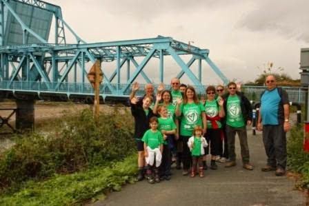
all boarded up now is testament to the HQ of the original owners of the steel works here at Shotton, The Summers family. this was the John Summers HQ. And so we crossed fields heading to the blue Jubilee Bridge (named for Queen Victoria's jubilee in 1897),
our destination. We had one last field to cross with cows….
Amy and I were not
too amused but all was well! We had our first sign with CHESTER on,
quite a shock to me to realise we
were really nearly at the end! We crossed the bridge to meet with Amy’s parents.
What a lovely day in the end! We had expected this walk to be tramping along the road but as usual the Path had more to offer! And I’m sure Amy will do the whole path too when
her PhD is finished. She has helped us today with our Welsh pronunciation – it
was fun. Thank you, Amy!
12.5 miles
Saturday 27th
September
Queensferry (Garden City) to THE END!
Wow – all the
family arrived last night and we all arranged meeting place for this morning.
Back to Queensferry Hotel to get together..........
and to meet Paul and Jane, our
friends from home, New Radnor coming to walk the last 6 miles with us. What lovely people after they only got back from holiday last night - and then had an horrendous journey when all roads leading to Chester appeared to be closed.
There we
were all lined up and ready to go, even Susannah at 3 years young. I was very proud of them
all.
We knew it would be a bit of a boring walk today – just straight along the
canalised river. Canalised to save
Chester
from flooding. And very straight it was – but not boring! We laughed and sang
and saw more lovely things – not including cyclists I’m afraid, they kept
getting in our way! Strange though that we were walking today with water to our right - that didn't seem normal! Had a chat with a man going the other way as we set off. He has just started doing the whole distance. I felt quite envious.
The bridge behind was pretty reflected in the river...
Herons were flying high and low,
oyster catchers were
flocking, cormorants were diving. I really have never seen so many herons all on one day....
The old wharves were silhouetted in the water...........
Looking back at the landmarks we had followed for 3 days, now behind us...
and then as we approached
Saltney footbridge, a wondrous thing happened. I turned to take pictures of the
Jubilee bridge and the power station and Flintshire road bridge (built in 1998 to take the A548 over the river, and very pretty it is) reflected in the
water and the water was making a different sight and sound….
the tide was coming in and
meeting the outgoing river and there was the Dee Bore!!!
I had read that the
Dee and the Mersey have bores similar to the famous
Severn
bore but never believed I would see it today! There it was!!! I was so excited.
Across the river here is the Airbus factory....
...and the landing place where the wings are shipped down to Mostyn...
Behind us the tide was already high with its lovely reflections still...
...and I was just so fascinated watching the bore head upriver....
..almost wanted to run to keep up with it, almost!
Soon afterwards we stopped for lunch –
the children were hungry! Typically just as we were eating lunch, it rained a
bit. This has happened a lot to Chris and me, just as we stop, we have a
shower. Still it wasn’t much at all and as we set off again it had stopped. We
went around the footbridge at Saltney Ferry now with lovely reflections and blue sky....
...we watched a water skier on the now full tide and cheered him..
and then before we knew it the end was in sight as
we turned a slight bend. The children ran ahead and had a green tape to put
across the path for the finishing line!!
It was strange to think this was
it..the end. think all I could do was smile...
What an amazing thing...all the family there, such support...
...and Paul had done a tremendous job as the main pacesetter all day...
I had been at the back mostly, in a way I think I didn't want to finish.
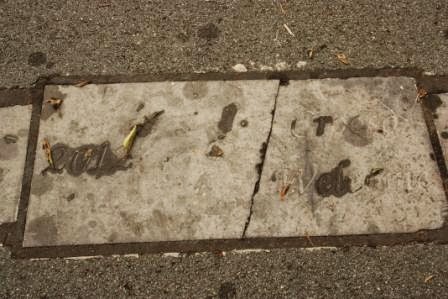
The signs here are a bit disappointing really. There are 2 stones, one at each side of the path with carvings on, now a bit indiscernible. On the
footpath is a stone with 2012 and Croeso on but the stone is now cracked.
And
the Welcome to
Wales
sign has been scratched away and looks sad. There is a stone with the coast
path symbol as you cross into
Wales.
But there was nowhere to sit down and reflect either before or after the path
is walked. We had to then walk about another mile, going back to a track leading
to the football stadium where the cars were.
What a lovely
day – celebrations were held with a meal all together that evening
and now Chris and I need
time to reflect….
4.85 miles
– excluding return to cars. Well done everyone!
I will be adding a conclusion to this blog with my facts and figures so don't stop checking back just yet.....
THANK YOU ALL!!!