Monday 10th February, 2014
After the wettest January since climate change began- not to mention a very soggy December too, and storms galore, we questioned our sanity as we set off yesterday...in snow flurries and passing flooded fields along the way. When we arrived at our lovely little house in Llanrhian however, the sun was shining. This morning we met the taxi man at Nolton Haven - just! We got a bit lost on our way there. He duly returned us to our last walk's end in Marloes ready for a short walk back down to the path at Musselwick sands. It was lovely to be back...if a bit muddy!

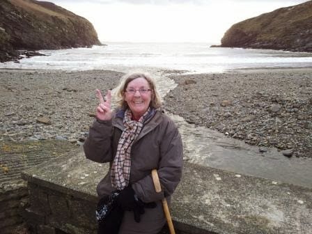
St Bride's Haven was the first of many Havens on our walk today and very pretty it was too. Here's Chris at the edge of the St Bride's Castle estate land. Now a holiday rental home...an upmarket one I believe.

The Bay has a pretty church and statutory lime kilns...a lot of them along the Pembrokeshire coast. And this Haven was a Mesolithic flint factory...hard to believe now.

The scenery was once more breathtaking and by now...the sky was blue and the sea was shimmering!


We had superb views all around St Bride's Bay - seeing as far as Grassholm out in the Atlantic and nearer to us Skokholm and Skomer of our last walk's familiarity and then right round to the walk yet to come out to St David's Head and Ramsey Island. Today there were 7 ships sitting in the Bay waiting for their call into that bigger Haven at Milford! We dropped down into Little Haven through a wood - the only wood this week, we have passed through so many little - and big - woods now. The sun was glorious.

Little Haven is a lovely little village with its own Cobb.


Soon we were going around Druidstone Haven which really is a pretty cove with a hotel and maybe 2 other residences. There did appear to be some kind of standing stone in a nearby field..was that the Druid Stone? As we climbed out of the Haven here, the views across the Bay were lovely.

The sky was lightening again and the sun shone between Martins Haven and Skokholm ...

as we approached our destination....Nolton Haven!
On the drive back, we passed through Roch. A little village with its own castle, unlike other Welsh castles we thought in its appearance.

Tuesday 11th February
After a storm in the night, we awoke to grey skies but dry so off we set to meet the taxi at Porthclais, our destination for today's walk, and off he took us to Nolton Haven. The taxi driver had lost his dinghy to a January storm as it was swept away from the Porthclais harbour.

It was a gentle climb out of the Haven to be met with a lovely sky and super views out over the Bay.

The gentle start hadn't lasted, it was to be quite a roller coaster of cliffs today, in and out of coves. The gulls were much in evidence today, whereas yesterday we had seen starlings doing their swooping.

On the approach to Newgale sands, we passed a chimney stack, another witness to earlier coal mining days.


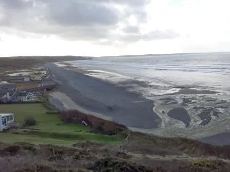
Newgale sands was an amazing sight. The local people are really upset that the sands are so strewn around after the storms. But we were really pleased to be able to see the ancient forest revealed. We were entranced looking at the ancient wood!


It was so hard to believe that only last week a bus on the road at the other side of the great shingle bank had been tossed aside by a huge wave...

We had lost some time doing our beachcombing so off we set again up over the cliffs to look back on Newgale. It was a steep climb over Cwm Mawr, again we could have gone around it if the tide was as it should have been...but then it is February and we can't complain!
It was a terrific walk over the clifftops as we headed now for Solva with views ahead to St David's Head and Ramsey Island at the extreme left.


Solva and the little bay immediately before it are linked by a hill called the Gribbin. The 2 bays were formed by glacial meltwater and their flat bottomed valleys are indeed testament to that. The Gribbin has an iron age settlement on top, not as clear to see as some have been. This is the first bay ahead of Solva with its pebble bank.

Solva is a pretty little harbour village. It again has lime kilns which was its main industry. Rain threatened as we went around the harbour front and climbed once more above the village...not easy whilst trying to eat one's sandwich! But the view back shows the twin valleys and the Gribbin clearly below.

Still quite a way to go as we headed now towards Caer Bwdy and Caerfai, close to St David's itself a little further inland, the smallest city in the UK. It seemed the map maker may have got her mileage wrong for today.....we passed another Iron Age fort and then a really clearly marked one just before we got to Caer Bwdy..hope you can make out the earthworks..

The Pembrokeshire path says it has 47 forts but we think it must be more surely. Wish we'd counted them now!
Caer Bwdy was another pretty little bay. The red sandstone had been quarried here to build the Cathedral at St David's.

Soon we came round to Caerfai Bay - here the Cambrian rock is the oldest in the UK at around 500 million
years.


Soon came round now to Porthclais - the original harbour for St David's with the sun now
golden falling in the sky.

Wednesday turned out to be as the forecasters had promised.......REALLY stormy. The wind just battered everything. Power cuts and all, not to mention thrashing rain in the morning especially. So taxi was cancelled and we just managed to stay upright for a brief walk around St David's..

Thursday 13th February
We arrived in Abereiddi this morning waiting for the taxi in some trepidation..not least because hail was falling! And a power cut meant we hadn't even had a cup of tea! The sacrifices made for doing this walk! We were duly returned to Porthclais (with its many lime kilns..) with the thought that we would get at least a few miles today...prepared to bail out if necessary...

So we were quite pleased when we got up on the cliffs to see that the sky was...could it be? ...breaking up? We were amazed as we gazed out to the sea and its increasing number of islands at the blue sky!

We soon came to our first Bay of the day at Porthlysgi. A very isolated bay and today much covered in flotsam and jetsam. There were several large buckets here that locals were obviously trying to use to get rid of the rubbish the sea has washed up....so many plastic bottles!

It was a marvellous walk up to St David's Head looking out to all the islands. There are so many little islands around Ramsey Island that they are just known collectively as the Bishops and Clerics. And I had great excitement when I spotted a chough! (I do have to admit that my photo wasn't this good as I didn't have my tripod with me...so I "borrowed" this picture...)

As we approached the end of the land, it was with a bit of a strange feeling. That we were indeed now leaving the south coast of Wales behind! We weren't exactly sure to be honest which headland really WAS the most Western point of Wales...

We enjoyed looking across to Ramsey Island with it s 2 hills Carn Ysgubor and Cader Rhwydog. Ramsey Sound does look quite foreboding with its heavy current and turbulation. I understand that in summer it is enjoyed by kayaks and jet skiers!

Very pretty walk around to St Justinian's which essentially is a lifeboat station...in a spectacular setting! There are also the ruins of St Justinian's Chapel.


..and just inside a dolmen, Coetan Arthur..

..soon followed by another one close by...

The landscape now was very rugged and remote and we were now quite high above the sea.

The gusts had gone though so it was a really enjoyable walk, heading now to go over the shoulder of Penberi!

Once around Penberi, we had clear views of Strumble Head beyond but knew we wouldn't reach it this walk, as we had intended...nevertheless we had lots to enjoy. Another fort loomed but was inland so we couldn't get a clear sight of it but we did see Castell Coch, fallen into the sea ....Chris though thought it looked more like a sleeping dragon......

We had passed so many coves these last 3 days, it's just impossible to remember them all. As we approached Abereiddi, some of the coves had obviously once been quarried. Not sure what the tower on the headland was for - a landmark perhaps for vessels?


