Monday 30 December 2013

Happy Christmas and here's to a good 2014!

Hello everyone! Hope you all had a lovely Christmas and that most of you avoided the floods and power failures...and to those who didn't escape, hope you have a good 2014! We are missing our walks by the sea but planning is going ahead. I had a lovely book for Christmas about the coastal walk with lovely pictures...although I do think some of mine aren't bad!
In Wales we had a white Christmas - an icing sugar covering on Christmas Day. Luckily it didn't stay very long! And we have been trying to keep fit with some good walks in the Radnor Forest. Here was the Whimble view yesterday...
Not sure when the next walk will be exactly yet but we plan to have 18 more - 3 of which will be 5 day events. You can guess our holidays next year! Can't wait.

Great news to report is that with the help of Nigel, our friendly landlord in the Radnor Arms, probably the greatest pub in the world, we counted the money from the collection tin which Chris has manfully carried for 328 miles now. And....the total amount in there was £208.30!!!!

I have already "declared" £98.70 of this on the justgiving page as offline donations from those who have given me their donation so that means there was another £109.60 from people who contributed over the walks. So pleased and thank you all so much for your support. I know Velindre are very grateful too and I am just happy to try to help them.

Take care everyone and have a good New Year celebration and here's to a happy, healthy, peaceful 2014 for you all!

Monday 18 November 2013

Walk 12 Pembroke to Marloes 13th-15th November, 2013

Well this was now definitely the last walk of the year...sad to say, but the snow may be coming in now! As in a quote Chris found today....."there is a fine line between hobby and mental illness"! I will begin though with giving the fundraising site as a reminder of why we are doing this....www.justgiving.com/Pamela-Mallpress
I know it has been a busy giving time with Children in Need and now the awful disaster in the Phillipines, there is so much we all would like to help with.

So we set off in the dark and minus temperature last Wednesday morning, arriving in Milford Haven at our chosen hotel, the Belhaven House, by 8.30 where we were picked up by the Call a Cab taxi and returned to Pembroke Castle, scene of our last completed walk!
It was by now a lovely morning and off we set with lovely views all around the mighty Pembroke castle. We followed the north of the Pembroke river through fields and then on a road into Pembroke Quay - quicker to write than to achieve! This part of the Pembrokeshire coastal path - from Angle to Sandy Haven past South Hook which we won't pass til tomorrow - is one that apparently lots of people miss out when walking the Pembrokeshire Coastal Path because of its industrialisation. But really they are missing out so much! There is so much to see. Pembroke Dock is full of information. The Dock really sprang up in the early 1800's to house the Navy and defend us from the French! We passed one of its Martello Towers close to Front Street - the first street to be built in the town to house the dockworkers.
On the wall next to the tower are plaques commemoratuing the history of the town, from its beginnings through to the Second World War when many bombs were aimed here and a Wellington crashed into the sea further downstream on its way home. Having had a good look around and enjoyed a coffee at K's Cafe, we set off to the Cleddau Bridge to cross the Abergleddau estuary. There is a further walk going further around the Haven, another 12 miles, which will wait for another time. It isn't part of the official coastal path.
The bridge was opened in 1976 (or thereabouts...) and is now the second bridge we've crossed so far, the first being on the A48 to Swansea - we're more used to going under them! But the view was terrific..At the other side of the bridge was the berth where HMS Warrior used to be moored.
We soon dropped down to the estuary side again and on losing the direction of the path at one point, we came across Brunel Quay just as we were entering Neyland. It was amazing to find that Brunel really created Neyland intending it to be the main dock for transatlantic ships. There had been a hotel here where many notable people had stayed, a railway leading to it, customs house and so on. The buildings have all gone as the dream never quite came true... although it is of course a leading ferry port for Ireland just across the water at Pembroke Dock. Interestingly, the Brunel ship, the Great Eastern, was docked in the estuary to undergo repair work - and that ship was almost as huge as the modern gas ships!
And today there is an Irish ferry in dock..
From Neyland we walked through the small and pretty settlements of Llanstadwell and Hazelbeach and then following the water as ever (at least here we were really never far from the water either which was excellent!), we climbed into fields above the estuary, still with good views and the light on the water was sometimes so stunning, as here looking across to where the river Pembroke joins the Abergleddau..
And here where a strange light hung over the newly opened (and much discussed) gas power station across the water!
We soon had to negotiate our way around the oil collection point and the new refinery which necessitated crossing some particularly scarey bridges! Trust me I was VERY brave to go across 2 like this!
It was all so interesting to watch the river traffic - as here where a tug was going out to sea, and maybe the harbour master in the lead alongside the terminal jetty - the Valero refinery in the background, it's been on our horizon for so many walks now! Shame there was no ship in dock today!
And yet on the right of the picture in the fields was the home of Hywel Dda...a long forgotten Welsh king...people have held the Haven for some time! We were soon heading away from the river a little to find our way into Milford Haven. Crossing one field of cows was fine ...until we exited the gate at the other side...
Phew! It's a risky business this coastal path walking!
We soon came round to Castle Pill at Black Bridge which is a lovely setting - we avoided road walking here and were helped with directions by a man walking his dogs who has walked the Pembrokeshire path 10 times!
And so Milford Haven was reached along the promenade, The Rath with its great views and its elegant houses and statues...here one is dedicated to the fishermen of the Haven and the other modern one asking the spectator to remember to look for reflections, quite inspiring!
And so to Hamilton Terrace and the Belhaven House, originally built as the home of a surgeon of the Milford whaling ships! And now it's the home of Bruce and his wife. Very friendly, and Bruce is a keen Arthurian devotee with lots to tell us about the legend! The place where Gawain died by the way was apparently Walwyn's Castle, near Sandy Haven close to where we will walk tomorrow, NOT St Govan's Head which we thought last time!

Day 2 - Thursday 14th November set off quite windy. Not as bad as the last walk though! Call a Cab led us to Dale to leave the car and drove us back to Milford Haven so we set off by 9.30. Not a lot of town left to walk through, having passed the harbour...complete with lock gate...and the famous torch theatre....
....we did see a few fishing boats alongside the marina and soon found our way to Gelliswick Bay, looking across once more to our old friend the Valero refinery at Rhoscrowther.
The Napoleonic forts keep appearing, there was one on the headland overlooking the Bay here on the left and then a huge one further along our walk near the South Hook terminal. And of course the forts on the rocks in the estuary - Thorn Island which we passed last time near west Angle Bay and Stack Rock fort just near South Hook on this bank...quite striking, the ancient and modern!
We soon began to leave the industrial parts behind as we came to Sandy Haven inlet where we knew we could get over the stepping tones as low tide had been at 10 this morning, otherwise we would have had about a 3 mile detour!
And much as I had discovered in Ogmore that stepping stones aren't necessarily my favourite things, I preferred them to a longer walk! To bravely go!!!!
We were indeed now back to the beautiful cliffs with their many shapes and hues and soon we saw the next ferry arriving. 
It was now a lovely day and we saw so many little coves and beaches. It's so hard to remember all their names!
Very soon we came to Monkshaven - the Bay where St Ishmael is said to have come ashore from Ireland as so many did bringing Christianity with them.
It is a stunning little bay and we had a chat with a local man who gave us the potted history. He told us that it wasn't so long ago that the waves crashed over the top of the wall that had been built across the bay..
We soon came around then into the Dale bay - at Musselwick and walked alongside the water on the rocky beach where we saw - and heard - a flock of oyster catchers.We knew that there was a plank bridge crossing here at the stone bank where the water meets the beach and seawater meets freshwater and that we were unlikely to have made it in time.....
...so near and yet too far - for me anyway! So a 2 and a half mile detour was made!! Sob Sob! In fact we had read that it is only a 2 and a half hour window each side of low tide to make it whereas in fact it was now 4 and a half hours since low tide..had we known we would have walked faster I'm sure! Never mind, we soon arrived in Dale - and very lovely it is too! 
The only downside that night was that the pub was shut - for the whole of November so we had to drive to the Lobster Pot in Marloes, not too far and a very tasty meal was had!

Day 3 - Friday 15th November. Allenbrook, our B and b for the night had been probably the best so far. Very lovely, huge, old house of the 17th and 19th centuries, homely and comfortable, providing a much needed good rest!
It was a lovely and still morning as we set off to get around the Dale peninsula - just hadn't realised how many peninsulas there are down here! As we got to Dale Point we were looking across to the Angle peninsula, scene of our last, windy walk and the light was once again spectacular! Sheep Island is there on the right with Freshwater West Bay and Castlemartin beyond.
We followed the coast around to Watwick Bay and Point and again could see West Blockhouse which had originally been Henry VIII's fort to protect the Haven (informed by his father no doubt....) but which had later been regenerated first as a Napoleonic fort and then as second World War fortifications. Next we came to Mill Bay - where Henry VII came ashore in August 1485 (his main army disembarked in Dale it seems).
It was fascinating to go down to the beach, not only to think about its importance to us all in Britain, a new king, but also to see a wrecked submarine!  A German one that had broken up when it was being towed into harbour for dismantling!
We climbed out of the Bay with fine views and rounded St Anne's Head. There had once been quite a large estate up here it seemed, could still see the wallled garden. There are also 2 old lighthouses - one now a ruin and the newer one now a private house - old-fashioned technology now radar is used. It was then just a lovely walk around the peninsula with the lovely views, great light on the sea and watching yet another ferry appear beyond Skokholm island ahead of us.
We soon came round to West Dale beach and it was amazing how narrow the peninsula is here - just a half mile walk to Dale!
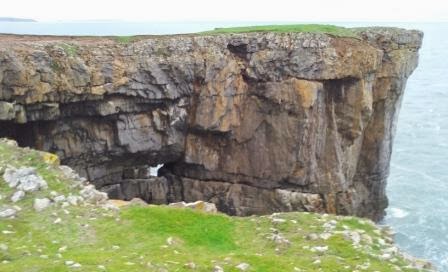
And here was another of the iron age hill forts which had mainly fallen into the sea again...
Just one lonely surfer was playing in the waves as we passed by - and were they puffin holes we saw in the cliffs? Certainly Skomer Island is renowned for its puffin population in the spring. We passed the old airfields which we could see the edges of and there were many walls made of broken up brick and concrete obviously from buildings long gone on the airstrips. These were the home of the aeroplanes protecting the shipping lanes in the war. But alongside them is the magnificent Marloes Sands.
 Such high cliffs that you can only safely get down towards the end of the bay, near Gateholm Island, where a stream has carved a way down. We did have lunch here. It is such a wonderful place with islands all around - Skokholm is just lurking there at the left and Skomer is just beyond Gateholm on the right. And all the edge of the sea is full of rocks - here all like pyramids. We followed the bay around and then looked down on Albion Bay (so named after a ship that wrecked here carrying pigs apparently! All were saved but the prop shaft can still be seen at low tide it seems) and Gateholm. It is the time of year to see seal pups - but none were in evidence for us today.
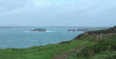
So we were approaching Martins Haven now - a National Trust centre. We could see the next hill fort - supposedly the most well defended in Pembrokeshire I understand but I don't understand how they know that when so many, as we have seen, have fallen into the sea. And we also now had view of St Bride's Bay sweeping round to St David's ahead of us! In the bay were 6 huge tankers - holding out for an increase in price? Perhaps! We were also soon overtaken by a skein of geese heading noisily for the island.
And here are some more of those weirdly shaped rocks, not concrete honest!
We first passed Jack Sound - the narrow strip of sea between the mainland and Skomer which is very turbulent and dangerous. 
And then at Martins Haven is a 5th century cross which was found here in 1984.
There had been a seal pup on the beach here a notice said but he wasn't apparent to us as we climbed out of the bay for a bit of a trudge around to Musselwick Sands - where our path would then lead us to Marloes a little way inland - the good thing was the amazing colour of the sea.
So Marloes was reached - we passed the Lobster Pot, scene of last night's meal..
 ....and luckily found the shop open with a coffee to go - truly a lifesaver (Chris's life that is!!). WE headed for Dale road and were soon retracing our steps of the previous day around the Pickleridge or Gann where land meets sea near the stepping stones. As we arrived into Dale at 5pm, it was dropping dark giving us our last view of our friend, Valero across the waters of the Abergleddau!
.Our hostess of the night before had been about to send out search parties as we got to the car!! It had been a long but thoroughly enjoyable day.

The walks of the last 6 days around the Angle and Dale peninsulas, reaching out into the ocean like fingers, protecting the Abergleddau with its many coves and inlets and its settlements including Milford Haven and Pembroke, deep inside it, has been so fascinating. The Dale peninsula in particular is so different on each of its sides. the eastern side, in shelter, with its banks rolling quite gently to the waters' edge whilst the western side is wild and fierce with its high cliffs, some like concrete, and its jagged rocks and islands facing ferociously all that the Atlantic cares to throw at it. We have marvelled over the last 6 days' walking, perhaps even more than in the earlier walks, at what a power and force nature provided to form the spectacular rock formations, some twisted, contorted and folded beyond belief. And then we have seen, particularly down this mighty estuary, how Man has imposed himself on this landscape he has inherited. Right from the early iron age forts to the ancient kingdom headquarters and the coming of Christianity to these shores. And then to the mighty castles - like Pembroke - that were viewed as necessary, to the fortifications of Henry VIIIth through to the defences of the Napoleonic era and so too those of  World War II. Now modern man is using this landscape with its deep, natural harbour, to provide the power - gas and oil - needed to sustain the 21st century way of life. Such stories!!

We now look forward to the remaining miles and the stories we can discover. 40 miles completed these 3 days so the total now behind us is 328! Only 542 miles to go!!

Thank you again for your support and encouragement and will speak again soon!

Wednesday 30 October 2013

Walk 11 Stackpole Quay to Pembroke 26th-28th October, 2013

So in spite of the dire storm warnings, off we set on Saturday morning on the 3 hour journey to Stackpole. That was one reason why we decided on a 3 day event this time, another being that we wanted to get to Pembroke and as this was likely to be a cliffy up and down walk, we thought 3 days would give us less mileage each day. Not that much fun driving down in the dark - and this time no sunshine appeared at daybreak. We arrived at Little Neath Barn, Rhoscrowther - our chosen bed and breakfast, and what a gem it was! We had a cup of tea with Mavis before she kindly gave us a lift back to Stackpole Quay. We had really been quite concerned about this part of the walk around the Angle peninsula and how we would manage the transport as it is such a quiet part with very little habitation (which is great!) but we hadn't needed to worry as Mavis and John, so kindly took us to each start point and picked us up at the end of each day - just fantastic and over and above their call of duty!
Having had many showers, we arrived at Stackpole in the dry and agreed our pick up point at Castlemartin - the range is open most weekends so getting as far as is allowed over the range is no problem today - hooray. I was so excited to be going to see the Green Bridge of Wales!  Stackpole is an amazing place having been a huge estate in its former glory and latterly as the land belonging to the Earl of Cawdor. The mansion was demolished in 1963 as the family were unable to pay the death duties. It was the scene of many grand visits including royal ones. So off we set from the lovely setting of the Quay, up to Stackpole Head. What a sight to set us up for the weekend - stupendous cliffs and crashing waves, it was fair enough quite windy! We passed many blow holes and sink holes - just didn't know there would be so many - they are quite scarey! And also so many natural arches - just whetting the appetite for the Green Bridge! We soon arrived at the beautiful Barafundle Bay which we had all to ourselves.
 This had been a private beach for the Estate.
It really was a beautiful morning!
With more marvellous cliff views, we soon arrived at the end of the impressive Stackpole Head. Still with views back to Caldey Island and even to the Gower and Rhossili Downs. What's more Lundy Island was clear for much of this morning!
The path ahead led us now towards the next beach walk at Broad Haven where the Bosherston lakes come down to the beach.
But before we got there, we had so much to see - and most of it involved the sea, funnily enough! IT was simply boiling in the wind - the spume flying through the air and nowhere more magnificent today than at the headland of Mowingword!
Just a bit sad that the photos don't do true justice to how it really looked...We wandered on past huge dunes and past enormous sinkholes, not for the faint hearted, and soon arrived then at Broad Haven beach. Not to ourselves this time but certainly not busy although the surfers were there making the most of it!

The bay here is dominated by Church stack out at sea - today the waves were making themselves felt out there.
The bay here was artificially made as a dam was built above the dunes so it is quite sheltered - and very pretty.
And so we headed on towards St Govan's Head still with many sights to see...a sinkhole here...
...and a huge inlet there...New Quay ...
We mistakenly thought that the well-known St Govan's Chapel was at the end of St Govan's Head itself so walked out there...
but it was well worth it for the view! We headed on now towards Trevallen at the landward side of St Govan's head and where the range was declared open but before setting out across it, we went down to the Chapel built into the cliff with the raging sea beneath - a terrific sight. Was it Gawain who had spent some of his later life here?
Off then across the track on the range. Passing Stennis ford and Huntsmans Leap - amazing inlets, the power of the sea....apparently a huntsman did jump over here in the 18th century and was so shocked when he looked back at what he had jumped that he fell off his horse and died! Good story anyway!
Less and less flowers to admire - and try to name - but many mushrooms and toadstools - whether they were field or magic, I'm not sure. What a shame that's a heritage we have forgotten!
Soon we arrived at Bullslaughter Bay. We think so named because of its red sandstone perhaps...or is that a huge toad in there...certainly there were lots of natural arches and "windows" to marvel at.
And the next beach was Flimston Bay. Beautiful but almost totally inaccessible unless you have ropes I should think.
Just before we approached the end of the cliffs for today, we passed what would have been the gatehouse for another iron age fort (can't remember now how many of the 47 around the Pembrokeshire path we have passed already). The main part of the fort has long ago fallen into the sea, only a few earthworks remain.
Then we arrived at the well-known Stack Rocks - or Elegug Stacks which are loved by seabirds in the Spring I believe - there were a few around today and guano evidence of overcrowding maybe! And so on to the Green Bridge - it didn't let us down. a lovely sight if a little blowy by now. Luckily there is a viewing platform all enclosed with a fence so we didn't venture out of it! We wondered how much longer it will be there.
So we left the coast now as this is as far as is allowed. There is a lot more coast to go to the West but this West Range is all on MOD land with public entry only allowed once or twice a year in the summer on guided tours. So we headed inland through the range, passing Flimston chapel and a huge former farmstead there which had been compulsorily purchased for the war effort....towards Castlemartin. Just as we came to the village sign, the heavens opened and the wind blew manically! We headed for the bus stop, our pick-up point and Mavis took us back to Little Neath Barn! A lovely relax and clean up in the very comfortable room after our 11 miles and 6 hours' walking before heading off for refreshment at the Speculation Inn just down the road - very good it was too!

Day Two saw us dropped at the Pound in Castlemartin to resume. The Pound was used in the 15th and later in the 18th centuries to hold wandering cattle for the owners to come back to pay for their release!
As you may see, it was a windy morning and the forecast was a bit grim but it was also very sunny so we decided to give it a go. We were well stocked up with a lovely breakfast anyway! A little walk out of the village led us to Freshwater West - well we could hear it well before we could see it! Never heard or seen anything like it before - what an experience!
Just at the edge of the sea is a seaweed drying hut refurbished to show the local history. There were apparently 20 or so of these at this beach where the seaweed was collected and dried on the floor before being sent to bakeries in the south of Wales to make Laverbread. Some mad souls were attempting to go in the water and there were a few walkers and joggers on the beach - all of us marvelling I think at the spume forming and being blown like snow. The noise was just terrific!
Freshwater West has been the scene of much filming...the last Harry Potter was shot here where they built the Shell House, now demolished, and the Russell Crowe Robin Hood was also shot here. No doubt others will follow - it is such a beautiful and remote setting.
As we climbed out of the bay, the rain came on heavily and we believed that would be the pattern of the day as we trudged through Pembrokeshire pink mud where a new path is being formed to avoid a part where there has been a cliff fall. 
The waves below us were just astonishing - once the rain stopped, we then had a few soakings from the mist of the waves crashing beneath us!

The rain however couldn't continue with the wind blowing it away so we had soon dried off. It was very windy as we rounded the cliffs to Guttle Hole - another stunning natural arch with the waves battling though it!
We had views of Sheep Island and then Rat Island as we rounded the headland to come into West Angle Bay and saw an Irish Ferries boat heading down into the Haven. Next came the view of Thorn Island just off the West Angle Bay. There are talks apparently of making this island into a superior hotel but no-one seems to know when.
And we also passed the East Blockhouse built by Henry VIII as one of the defensive points of the Haven - we will have to look out for the Western one when we are at the other side of this massive harbour!
It was quite a relief to drop into the shelter of West Angle Bay even though Chris succumbed to a comedy fall......first aid was at the ready! After a brief lunch we climbed out of the bay. There is opportunity here to take a shortcut into Angle village by cutting across the end of the peninsula - but we don't do shortcuts! And glad we don't, we still had much to see. We passed Chapel Bay which was used to look out or listen for U boats in the War and soon saw the big 300 metre long big! gas ship disposing of its cargo. There is a Fort Boyard look alike in the Haven here too, another Napoleonic fort probably like the one on Thorn Island.
The Valero oil refinery at the other side of Angle Bay and near to Rhoscrowther was growing larger now, it had been on the horizon most of the day and we could see St Mary's church tower in Angle - our rendez-vous at 4 pm. First though we stopped at The Old Point House pub as we rounded into Angle Bay for a welcome coffee.
A lovely old pub where apparently the fire has never gone out - for a long time anyway - in the old type range. And lovely people there too. Ian and Richard had a chat with us about the lifeboat here - the station was just further up the path which we had just passed. and they very kindly donated to our fundraising - thank you very much! Off we went along the potholed track which on high tides in the Spring becomes submerged. Lovely little harbour here and the Tower dates back a long way - it is the equivalent of a peel tower - very rare in Wales.
It is a lovely, interesting village. John picked us up and back for a relax after our 6 hour walk - what a great day! And the Speculation Sunday dinner was most enjoyable!

Day Three - well the threatened storm appeared to have been yesterday afternoon for us. The news had managed to make sure not many people would go to work in the South East this morning. We had heavy rain in the night and so kind of expected to get wet today walking into Pembroke.....So after a hearty breakfast, John dropped us once more in Angle and off we set along the bay.
It was a beautiful, still, sunny morning as we headed around the bay.
We headed towards the oil refinery which had looked like a Christmas tree at night. Although it is maybe not a pretty sight, it is needed so we have to put up with it and today it wasn't too smelly until we went past it to the other side and even then it wasn't terrible. We passed lots of birds at the edge of the bay - oyster catchers, ducks of a sort I can't name, white egrets and even swans!
And we could see the Old Point House for a long time as we looked across the water. And on the horizon was Rocket House which we passed with John this morning. It was used before coastguards were invented as a warning that someone may be in trouble on the Haven - there was a look out who would send up a rocket (flare - not a space one!). It's the white house on the horizon here...now a holiday home..
We headed then away from the Bay and towards Fort Popton and then some up and downs along the road - quite a lot of ups and downs today surprisingly! We passed under the pipes (21 Chris said) taking the oil ashore to the refinery - Chris's favourite bit today (!)
And the views down the Haven (the Daugleddau estuary in truth) were amazing. But one has to wonder what the aim is when wind turbines (turned off today because the wind's too strong no doubt...), see them on the horizon there?, are sitting across and alongside all these oil and gas terminals...........
Wandering through woods alongside the estuary was quite pleasant and soon we passed through an old settlement, Pwllcrochan. Just a church and old school room - now a site of scientific interest with its bats and otters. From here we decided to stay on the tracks to avoid mud and so left the official path here and there. The hedgerows here didn't appear to have any hawthorn - mostly little ashes and bracken intertwined with ivy and bryony.
Soon we were entering Hundleton where we dispensed with waterproofs which were actually only muddy - no rain to speak of! Dropped down then to Quoits Mill Pill which joined the river Pembroke here and headed through Monkton and into Pembroke!! Walk complete and a lovely view of the castle....
....birthplace of the Welsh king of Great Britain, Henry VIIth. After lovely food at Williams, a new food place on the High Street - and very good it was too (much needed too after the 12 miles and 5 hours walk), we met with John again who returned us to the car for the journey home once more. Thank you again Mavis and John for a lovely stay and for your support and donation.

Hope that all wasn't too long and boring - not used to 3 days!! Still standing anyway - and already looking forward to the next one - can we fit one in next week? Perhaps......